
Garmin GPSMAP 66i, GPS Handheld and Satellite Communicator, Featuring TopoActive mapping and inReach Technology, Multi
From the manufacturer

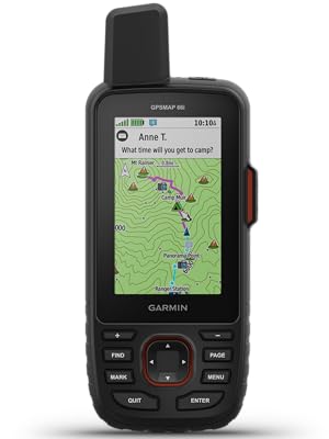
Garmin GPSMAP 66i
GPS Handheld and Satellite Communicator

NOTICE: Some jurisdictions regulate or prohibit the use of satellite communications devices. It is the responsibility of the user to know and follow all applicable laws in the jurisdictions where the device is intended to be used.
Rugged GPS Handheld and Satellite Communicator with Garmin TOPO Mapping
Precise Garmin navigation meets global communication in the GPSMAP 66i premium GPS handheld with inReach satellite technology.
- Large 3” sunlight-readable color display for easy viewing
- Trigger an interactive SOS to the GEOS 24/7 search and rescue monitoring center; two-way messaging via the 100% global Iridium satellite network (satellite subscription required)
- Preloaded Garmin TOPO mapping with direct-to-device BirdsEye Satellite Imagery downloads (no annual subscription); includes multiple Global Navigation Satellite Systems support and navigation sensors
- Cellular connectivity lets you access Active Weather forecasts and Geocaching Live
- Compatible with the Garmin Explore™ website and app to help you manage waypoints, routes, activities and collections, use tracks and review trip data from the field
- Internal, rechargeable lithium battery provides up to 35 hours of battery life in 10-minute tracking mode and 1-minute tracking mode (display off); 200 hours in Expedition mode with 30-minute tracking
Features and Benefits
|
|
|
|
|---|---|---|
Satellite CommunicationStaying in touch is vital, even on less challenging trips. Using inReach technology (subscription required), this handheld lets you trigger an SOS to the GEOS 24/7 emergency response team for interactive support in an emergency. It also enables two-way messaging and LiveTrack location sharing via the 100% global Iridium satellite network, so you can stay in contact with loved ones, teammates, headquarters and more. |
Weather AnywhereWireless Cellular connectivity lets you access Active Weather for up-to-date forecasts, including predictive maps for temperature, wind, precipitation and clouds — right on the handheld when connected to Garmin Connect Mobile. |
Pair with Your Mobile DeviceThe free Garmin Explore mobile app lets you plan, review and sync data, including waypoints, routes, activities and collections. Review completed activities while still in the field, even when you’re off the grid. The app also lets you sync your GPSMAP 66i with your compatible mobile device so you can access unlimited maps, aerial imagery and U.S. NOAA charts. You can even use all of the inReach features on your paired mobile device. For easier messaging, you can access your phone’s contact list from the Garmin Explore app to connect with fewer keystrokes. Plan for future trips and review previous activities from the Garmin Explore website. |


Specification: Garmin GPSMAP 66i, GPS Handheld and Satellite Communicator, Featuring TopoActive mapping and inReach Technology, Multi
|
10 reviews for Garmin GPSMAP 66i, GPS Handheld and Satellite Communicator, Featuring TopoActive mapping and inReach Technology, Multi
Add a review


$476.30


![Pelican Protector – Airtag Holder / Case with 3M Adhesive Sticker [1 Pack] Protective Shockproof Cover for Apple Air tag – Hidden Stick On Mount For Bike Wallet Travel TV Remote Car Luggage – Black](https://cartizzle.com/wp-content/uploads/2024/03/61hiLrfvRpL._AC_SL1500_-300x300.jpg)

tcp100 –
This is the first true full-featured GPS navigator with a satellite communicator built in. Realize what you’re buying into, and it’s a fantastic device.The original InReach devices were ostensibly marginal at being GPS navigators, that being a secondary trait of what they do. That isn’t the case with the 66i. The 66i has all of the top-of-the-line features of Garmin’s best handheld units.That being said, there has been a lot of talk of the “pros” and “cons” of this device. Let’s go through them one by one.1. Price: This thing is expensive for a GPS unit, but in my mind it is NOT expensive for what it does. I used to carry a Globalstar satellite phone when going in remote areas. That was a $350 phone with a $60/month plan – and it didn’t do much but make phone calls, and it wasn’t great at that. No location updates, no SMS. Purely for emergencies. Of course, I also carried a $350 eTrex at the same time. For $700 and $60/mo, I got SOME of the features that the 66i gives me in one device – for $600, $25/mo, and LESS WEIGHT, being key. Add in the weather reports (more on that below), location broadcast, and general utility of non-emergency SMS, and the utility is so much higher. All that and a better screen than the eTrex. Don’t compare the price of the 66i against one device, you need to compare it against two devices at once – a high end GPS AND a satellite communicator.2. Battery Life: The 35 hour claim is accurate, and Expedition Mode is a must. 20-30 minute track points are perfectly adequate, and you shouldn’t be leaving this on overnight anyway. You can get about 3-4 active days from the unit with moderate settings, and that’s good for most outings. Going longer? A simple power bank is something you should have with you anyways as essential gear.No, it doesn’t take AAs. Outdoors folk seem to have this obsession with AA batteries. 15-20 years ago it made sense, but it just doesn’t anymore and people need to change their mindset. I also carry a flashlight with a lithium battery and USB charging port (Acebeam and Thrunite have excellent models) that is brighter and lighter than an old fashioned AA model. The long and short of it is this: AA batteries have extremely poor power density. The power density (power per gram) of lithium simply isn’t beatable. 35 hours on the 66i can be doubled with juice to spare for other devices by taking along a power bank. That power bank is the equivalent of 20-30 AAs. Lighter, less weight, more power, more versatility. Cheaper after a couple of outings, too. The battery life of the 66i is perfectly good considering you can easily charge it back up overnight and go another 3-4 days. By the way, the issue is that this thing transmits – hundreds of miles into space – whereas your ordinary GPS is only a receiver. This takes an order of magnitude more power than receiving. A lithium rechargeable is the only practical way to go, and life will depend on how often you transmit.3. Firmware: Garmin is working on merging their acquired InReach (from DeLorme) infrastructure into their own. The 66i is the first unit released after that transition started, and it’s intended to be a native Garmin device. With that, some software features were delayed. These have now mostly ALL been fixed. You CAN now receive weather over InReach. The branding (“InReach Weather” vs “Active Weather”) is a little confusing – but all you need to know is the first is satellite and is text/table based, and the second is WiFi or via your phone Bluetooth and has radar maps. Radar maps are not currently a thing over satellite – but the detailed hourly satellite forecast is nearly as useful, as it derives from DarkSky which specializes in “hyper local” weather.Expect continued firmware updates, as Garmin has historically been excellent about this (the 66i is the 14th Garmin device I’ve owned over 25 years) – and make sure to keep your device up to date. I always check for updates a couple of days before I go out.4. Multi-GNSS: This is a little confusing right now, but as someone who actually works in the satellite industry and has specifically worked on the GPS program, I hope I can clarify a little. Right now there are four primary satellite navigation systems out there, each with their own satellite constellations run by different govenrments. The USA’s GPS is obviously the oldest, but there is also Beidou from China, GLONASS from Russia, and Galileo from the EU. GLONASS was the second system to be available to consumer devices, and Galileo is the most recent.Being more modern, Beidou and Galileo claim to have slightly better accuracy than GPS, but we’re talking a matter of a couple of meters. Additionally, the US’s GPS has traditionally been augmented by a secondary system, WAAS/EGNOS, which is a GPS accuracy enhancement system that largely makes up for that difference.In order to enhance reliability and accuracy, in the last few years consumer devices have supported receiving signals from multiple systems, as backup/redundancy and an accuracy enhancement.Whereas most early multi-system GPS’s supported GPS+GLONASS (such as the eTrex line), some now support there (the eTrex X series supports GPS+GALILEO+GLONASS). The GPSMap 66i supports GPS+GALILEO – but surprisingly to many, not GLONASS.In short: the reason this is the case according to Garmin is that the Iridium satellite network uses frequencies very close to that of GLONASS, and optimizing a receive / antenna system for GLONASS and Iridium proved too difficult. Even shorter: you’re not going to miss it.Yes, GLONASS is a more mature system than Galileo, but GPS+WAAS/EGNOS by itself is perfectly quick-acquiring and accurate by itself. Adding GALILEO makes this even more so, and as someone who literally builds radios for satellites for the military as his day job, a three-system unit is pretty much overkill. We’re talking literal inches here. You’re hiking, not flying a surgical strike with a drone. It’s not worth the battery drain.Could Garmin have done something like a dynamic notch filter to switch GLONASS on and off during iridium reception? Sure. Would it be worth cost, complexity and battery impact it could add to the device? No. You’ve already got a device that can use GPS, Galileo, WAAS, Iridium, Wifi and Bluetooth. That’s a lot of radios in one device, and it integrates them well.And last, some clarifications:- Garmin doesn’t word it well at all, but with the freedom plans you can suspend your subscription indefinitely. Their marketing material says you can suspend on a “monthly basis” which makes it sound like you have to sign in every month and suspend or it’ll renew again. That is not true. It stays off until you turn it back on. By “monthly basis” it just means that’s the smallest amount you’ll get charged for when you turn it on.- The ability to send preset messages that don’t count against your plan is huge. This will cover 80% of messaging use cases for most people I’d guess. You get three messages.. and you can attach your current location to all of them. Setting them to something like “Heading out” “Everything is OK” “Stopping for the night” covers most of your check-ins.- I have noticed a bug in the 5.90 firmware where the device restarts when switching WiFi networks or turning WiFi on and off. Not a big deal, but if you see it don’t think your device is broken.- The ability to download the BirdsEye imagery, which is free with the device (and got a major quality improvement in February) is super convenient. This lets you download without having to return home to a computer, so if plans change on the way, you can add images.- In addition to the built in topo maps, The 66i supports OpenStreetMap as well – which is gotten massively better in the past few years.- The SOS feature is backed by GEOS, an actual organization that coordinates rescues – so you aren’t just sending an SOS to your friends or to the local park ranger. This is a professional group. That being said, there is an option to pay $24.95 a year for $100,000 of “rescue insurance”, and options to upgrade for even more. If you’re the type of person who can justify this device, I’d highly consider it. It could save your financial life if you need to use it, and it supports an important organization if you do not.Summary: Overall, this is a wonderfully integrated and convenient unit with a few early-release quirks. It’sdefinitely not for the casual day-hiker and with so much technology integration, there is a learning curve. But that’s okay. The battery life is manageable and easily augmented, and the InReach feature can literally be a life saver. To be honest, this is the kind of device I had been waiting for. If you’re going to spend time in truly remote areas, I think it’s a must.
B.N –
I primarily bought this for the Inreach 2-way satellite messaging capabilities, and it works well for that purpose.The navigation is also a decent backup option for when your phone doesn’t have cell service. The device is very rugged and appears to very well made. It’s running on older legacy software, so don’t expect it to be like a smart phone. Are there fancier options with likely better interfaces, probably. But this is a very reliable platform, and likely a secondary backup device that you can rely on
Amazon Customer –
This is probably the best handheld GPS you can currently buy. I have owned Garmin GPSMAP 60, 62 and 64 series handhelds and this is hands down the best of the bunch. There is virtually no wait time for satellite acquisition and it is dead on accurate even under dense tree cover.I use it primarily for recreational hiking and geocaching. Familiarity with earlier GPSMAP units kept the learning curve on this unit short for me, about an hour of tinkering to get the menus and fields set up to my liking and I was good to go. Seems earlier reviews had complaints about software issues, seems numerous software updates have fixed those problems – aside from one random shut down I have had none. Battery life is acceptable for my usage, although I do wish Garmin made the battery in this unit replaceable. After a 12 hour day I still had 66% battery life left, more than suitable for weekend warriors. Although I do now keep a battery charging brick in my pack just in case.Enjoying some of the upgraded features from previous versions. Sharper and larger screen, geocaching live, birds eye view maps (on the fly) etc. Charging and connectivity is now via a micro usb, although I do wish Garmin had gone with a modern USB-C still an upgrade from the old style micro usb that was on earlier units.Despite a few minor flaws I am still giving this a 5 star review as they do not detract significantly from what is an excellent handheld recreational GPS reciever.
Mandingo –
It works great for hiking, dirtbiking, mtb, motorcycle riding and i use it for hunting also.
Mark Pernicano –
It’s very well built Great in the hand. It’s Advanced so spend some time learning how to leverage ALL of its capabilities.
RON –
I received this unit quickly. I bought a subscription, but it did not activate. I was flumixed……..(no, actually pi…). I depleted the battery twice trying to activate. Finally, I went to the activation sign in, and found that I missed a step. I filled it in, and am now up and running.P.S. Worth mentioning.During my kerfuffle with the activation, I was reading the box looking for whatever. Then I see that this unit is for IOS, not Android ! PANIC (once you register the Sat. plan, you cannot change units). So does that mean that I just blew ~ $230.00? NAH! That couldn’t be! So, I started reading the ink off the instruction book. it turns out that you HAVE to load Garmin Explore, AND Garmin Connect on your smart phone before you can access the unit for updates, and to be able to connect to your Windows / Android devices. You also must synch your phone with the Garmin Connect app. (MIGRANE!) It also helps to add GARMIN EXPRESS to your Windows computer. Plug the GPS into your windows laptop, and let Garmin Express do it’s thing. HAVE FUN!UPDATE;UNIT FAILED ! It used to lock on satellites in less than 30 seconds. then, after I had a service plan for rescue, etc. I turned on the unit and it kept timing out trying to locate satellites ! I hard booted, dumped all info and re activated, etc. NO GO, still could not locate satellites. The unit is being returned. So, now I am out for a months service on my sat plan. NOT A HAPPY CAMPER.WARNING…..I put a hold on my sat plan when the unit failed, they are NOT HOLDING THE PLAN UNTIL SEPT 8 !!!SO, I AM SCREWED FOR WEEKS OF SERVICE THAT CANNOT BE ACCESSED BECAUSE OF A FAILED UNIT. I ORDERED A 750 I, PAID FOR IT, AND HAVE NOT HEARD A WORD ABOUT IT SINCE ORDERING ON 8/8/20 !WHHAT’S UP GARMIN???Ron
Big Pa –
This arrived with firmware version 2.3 and during setup it updated to 3.1. That concerned me, but performance has been rock solid. I’m not using the bluetooth-to-phone capability, just basic navigation, since if I happen to have cell signal, I can just use my phone. The GPS locks on fast. The topo map it comes with is accurate but doesn’t have tremendous detail for the trails I frequent. So I purchased the 24K SE US topo for $20 and it has significantly more detail. With a cheap 32gb microSD card you can add a ton of maps. This unit is unbelievably brighter, sharper and faster than the eTrex I’ve retired. Battery life seems about the same; they were both rated for 16 hours. I’ve not found the BirdsEye Satellite Imagery to be particularly useful. Very high price but thankfully, it seems to be worth it.
Zachariah –
My 13 year old son and I started doing backpacking camping. We are working up to doing a 100 miles ground covered backpacking trip someday. This device has given my son’s helicopter mom the ability to have the peace of mind that we are doing everything in our power to be as safe and prepared during our adventures. She loves being able to check our location, get updates on our progress, and text us when she has a bad dream of us getting eaten by a wendigo. Thank you so much for helping with our delusion of freedom.Functionally it is also easy to use. Just like most modern cell-phones but it is not touch screen. No matter how many time I try. There are so many different features or additional “apps” on the device that I have not used yet but are fun to look at. I also picked up a protective case and screen protector for it. On the first trip out I dropped it on a rock right on the only part not covered by the case, the top of the antenna, and though it clearly is used now it still is working just fine.The additional weather info on it is great. We had a trip planned and had a mild blizzard move in and we where able to track the weather on this device to give us the confidence that we were not going to get ourselves in a situation beyond our capabilities. Got to have the experience of wake up to nearly 8 inches of snow in the morning.
Wolfgang Stiller –
I was hesitant to buy the 66sr after some of the other model 66 reports of buggy firmware but I researched this by googling the gpsmap 66 bug list. I see the the significant bugs have been corrected and this matches my experience. I purchased two model 66sr receivers and gave them a thorough workout but using multiple maps (the built in active top, the free OSM maps, and birds eye imagery loaded using Basecamp). We both used them for a long on-trail and off-trail hike and even did some geocaching. The two units worked flawlessly!One big benefit is that I found I could get a good GPS position in situation where I could get only a poor position (or none at all with an unlucky satellite positioning above me).(I have owned a number of previous Garmin and other brand GPS receivers.) I have been using GPS receivers since they were first available and the 66sr is the best currently available. Why? It has the best accuracy with it’s multi-band support (not the 66i does not have this and since I carry an InReach Mini, the 66i would have been a step down for me. If you don’t have an inreach device then the 66i may be of value even though it doesn’t have the enhanced accuracy and reliability.
Gene C –
Previously had inReach Explorer + – great device for emergency comm, light on GPS functions.The 66i is more GPS than emergency comm, can now be completely off the grid and have navigation, text communications and peace of mind.